Nolan's 14
Part 7 - Mt. Princeton
I had already decided before climbing Yale that I would not attempt to go on to Princeton. This left only Blake Wood in the race. I had enough experience on this mountain from a 12 hour climb on the north side on June 24, and an 8 hour climb on the south side on Aug. 8 to know that it would be unlikely that I could climb this difficult summit within the 5 hours remaining in the race. The photos below are from those two training runs.
After Blake Wood descended Yale to the Avalanche trailhead at 1:37 AM on the second night, he slept for the first time, and started toward Princeton at 6:11 AM. There is a long hike from there on good, mostly flat trail to the northeast ridge, which he reached at 9:36 AM. From there, he climbed the off-trail ridge, which involved some bushwacking, to the summit at 12:30 PM. He then descended the difficult Grouse Canyon route to the south, intending to go on to Antero, and reached the trailhead at 3:15 PM. At that point, he changed his mind about the 10 miles of uphill jeep road to Antero and stopped after 11 summits.

Mt. Princeton from Maxwell Gulch. The northeast ridge (Blake's route) is to the left. The mountain is steeper than it looks, since the camera is pointing up.

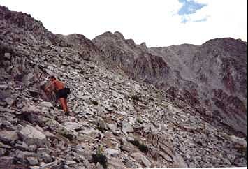
Here you can see how steep it really is climbing up to the northeast ridge. As I climbed the 1000 vertical feet, a storm approached.

The summit (left) from the northeast ridge. During my training climb, there was a hailstorm and my hair stood on end when I tried to climb near the top of the ridge, so I had to stay on the steep slopes below to avoid the lightning. There was no safe descent route except to traverse the summit, which was crowded with people.
I summitted just after the storm passed, and nobody was there. They had obviously left in a hurry, as the summit register was wadded up in a ball and stuck halfway in the tube. One climber later told me he abandoned his ice axe, not wishing to carry a lightning rod.

Here I am near the summit in better weather on Aug. 8.

The east ridge of Princeton, showing the class 2 trail, the usual route taken by most people, but useless for us. It would take us several miles out of the way.

Descending the west ridge to point 13,971. I did this section on Aug. 8 with Doug Millar, who was training for the Leadville 100. He didn't believe me when I said that this 7 mile round trip run from Grouse Canyon would take us 6 hours. He was right. It took us 8 hours.

Approaching point 13,971. From there, we descend the ridge to the left.

During our initial climb, our first problem was how to get past 13,971, seen from below.

We first tried to skirt the ridge on the inside, on the southeast side.


This lead to a dangerous traverse, dropping thousands of feet.


We decided it was safer to go over the top.

This is the route Blake Wood descended. However, to have any hope of finishing in 60 hours, it would have to be done at night.

Once below 13,971, the main danger is getting lost among the many diverging ridges. Doug and I both managed to do this, gettting separated and then forgetting the route that we had climbed.

The trail is steep all the way to the bottom, dropping 5100 ft. in 3.5 miles.
On to part 8
Matt Mahoney